Basel - Location and climate
Climate of the city
The climate in Basel is characterised by mild air temperatures and sunny weather with an annually average temperature of 11.5˚C. Warm and humid air masses from the Mediterranean reach Basel via the Burgundian Gate between the Vosges and Jura mountains.
Shielded by mountain ranges to the south and southwest, there is less rainfall in Basel compared with the surrounding area. Annual precipitation is in the order of 842mm, with about half the amount falling between May and August as convective precipitation. The winter months December to February are usually characterised by mild temperatures compared to other parts of Switzerland. The nighttime air temperatures fall only slightly below freezing point with an average of -1.5˚C. During the winter months, Basel experiences an average of four snow days. With temperatures increasing towards summer, the amount of convective precipitation and frequency of thunderstorms increases.
In Basel, on average 52 summer days (Tmax > 25 °C) are recorded. The daytime temperature in the summer months June to August can reach above 35°C. During heat waves tropical nights (Tmin at night > 20 °C) can occur in Basel. The daily air temperature amplitude is especially large in autumn, with warm temperatures during noon and cold temperatures at night. In autumn and winter, fog typically lasts longer in the Rhine valley than in Basel. Fog in Basel is frequently cleared in the early morning hours by the “Möhlin-Jet”, a local south-easterly wind system where air gets funneled by the Rhine valley topography east of Basel.
Topography of the city and land surfaces
The city of Basel is located in the Rhine valley and is surrounded by the mountain ranges of the French Vosges to the northwest, the German Black Forest to the northeast, and the Jura mountains to the south. The lowest altitudes are found along the Rhine river while districts in the south, like for example “Bruderholz”, are elevated. The zoo of Basel forms one of the largest green area in the city center.
With a population of about 180,000 and an area of 37sqkm, Basel is quite densely populated. However, many districts have small green areas and gardens. Public parks, such as Kannenfeldpark in the west of the city and Schwarzpark in the east form the largest green areas within the city boundaries. Districts in the southern and eastern parts of Basel are less densely populated as compared to the rest of the city.
The city has few high buildings; some high housing estates can be found in the east as well as in industrial areas on the periphery. The main railway station of Basel with its extensive array of tracks is located in the city center. A second large train station is located in the north of the city. In addition to the railways for public transport, some industrial tracks cross the southeast of the city. The international airport Basel-Mulhouse-Freiburg is located northwest of Basel on French territory. Cold air flows caused by mountain slopes near St. Jakob in the east and the zoo of Basel in the south influence the climate conditions of the city.
Urban climate differences
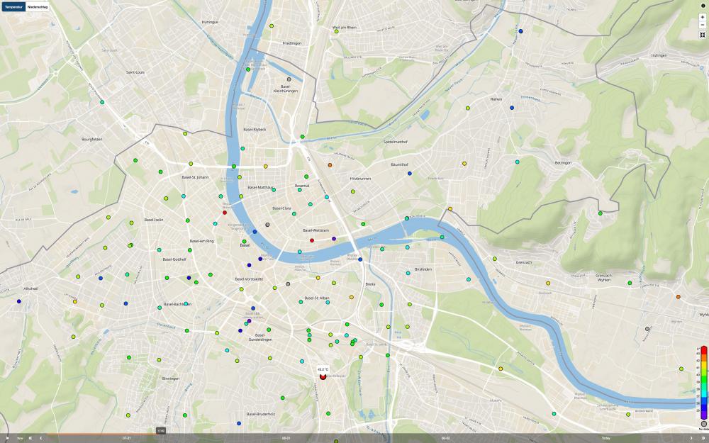
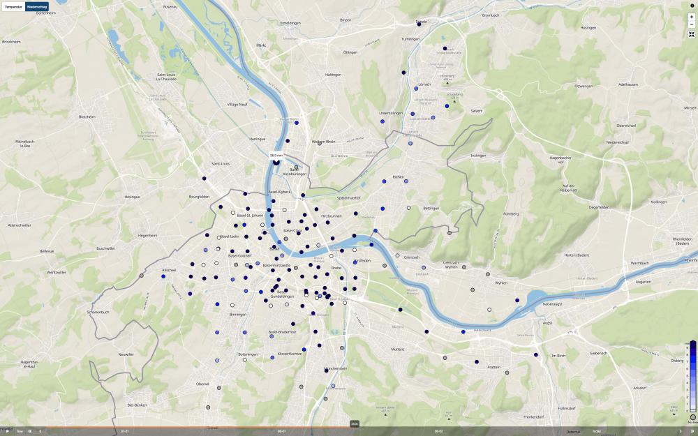
Some examples of urban climate differences in Basel, Switzerland, are shown in the graphics below.
Temperature differences exceed 5°C within a city and reach almost 10°C on hot days. On 31 July 2020, temperatures measured at 17:00 CEST were between 34 and 43°C.
Precipitation differences are also substantial: we observed repeated events with quantities measured across the city differing by more than factor 2x.
Further information will be published as the project progresses.
