City climate services
- Top precision: Scientific verification of our unique city climate model conducted over 3 years shows a model error below 1°C for temperatures calculated between weather stations. Our 24h air temperature forecast has the accuracy of 1.2 K, effectively providing the most precise forecast possible for any city location.
- Artificial intelligence: The meteoblue city climate monitoring system uses proprietary artificial intelligence to combine in-situ meteorological measurements with satellite data and numerical forecast models to produce precise data with a minimum of sensors, and in the most economical way.
- Seamlessly from history to forecast: We offer historical data, real-time updates and a 7-day forecast for any location within a city. Additionally, we use climate projections to estimate the air temperature and precipitation for different future time horizons (e.g., until 2050) pertaining to different emission scenarios.
- High resolution: Our city climate models have a horizontal resolution of 10m, and resolve the entire micro-scale variability of air temperature and wind velocity fields, bringing precise weather information to each doorstep.
- Multiple meteorological variables: We offer measurements of multiple meteorological variables (air temperature, relative humidity, precipitation) and provide modelled wind speed and direction at high spatial resolution for a wide range of applications.
- Multiple interfaces: Our products are available via API, FTP server, web, and app, offering you easy plug & play access to all possible applications.
Measurement network
- Meteorological IoT sensors from our partners
- Station installation plan
- Recording of relevant metadata
- Installation and Maintenance of the Network
- Data transmission via IoT technology
Measurement quality assurance
- Access to the meteoblue measurement API
- Uniform timestamps
- Temporal and spatial quality control
- Monthly reports and meteorological statistics
- Data homogenization and radiation correction
- Gap filling
- Real-time alerts
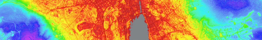
Heat maps
- High-resolution air temperature maps resolving urban heat island effect based on artificial intelligence
- 10m horizontal resolution
- Available for day/night and summer/winter conditions
- Analysis of heat maps by local climate zone
Town planning scenarios
- Point-specific analysis of changes in air and surface temperatures based on surface energy models
- Testing more than 20 different climate change mitigation scenarios
- Testing different scales of adaption measures
- Analysis of temperature change for different atmospheric conditions
Validation of mitigation strategies
- Based on measurement network
- Provided for several locations within the city
- Decision tool for monitoring the strategies in the city
Climate prediction
- Location-specific climate risk analysis
- Consideration of four future RCP emission scenarios
- Available until the end of 21st century
- All key weather variables
- Reference period based on the dataset ERA5
- Yearly and monthly aggregations
- Typical and extreme meteorological years modelling
- Spatial resolution of 10-30km
- Downscaling options
