
Katihar - Cho Oyu
Katihar - Cho Oyu
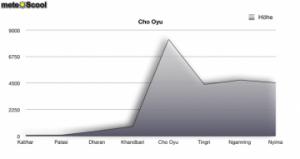
We are in Tibet, where one of the highest mountains in the world is located, the Cho Oyu (8201 m asl). Let's compare the temperatures at the peak of the mountain with the temperatures of places in the surrounding region. Weather diagrammes are shown for the peak and the following places (with altitude above sea level: Katihar (20 m), Palasi (52 m), Dharan (349 m), Khandbari (794 m), Tingri (4349 m), Ngamring (4722 m) and Nyima (4503 m). The results are shown below:
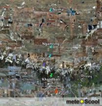
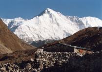
The two pictures on the left show the region around the Cho Oyu. In the first picture, the stations are held by pins on a map. In the second picture, you can see the mountain Cho Oyu as a photography.
Katihar (20 m asl)
Katihar is the lowest of the eight places shown in this journey past Mount Cho Oyu. You can recognise this - immediately - it is also the warmest place.
Palāsi (52 m asl)
The city of Palasi is not situated much higher than Katihar. This can well be seen by the temperatures: they are close to those at Katihar.
Dharan (349 m asl)
Compared to Palasi, the temperaturess in Dharan are lower. The difference in altitude to Palasi is higher than the difference from Katihar to Palasi.
Khandbari (794 m asl)
Here can be also seen a quite high difference. The temperatures fall even more. Compared with Katihar the temperatures are quite low.
Cho Oyu (8188 m asl)
At the highest point of Mount Cho Oyu, at 8188m altitude, of course, the temperatures are the lowest ones. But the reason why they are so much lower than in the previous locations is that the mountain get higher very fast on this side. For this, you have to look only the altitude of the places.
Tingri (4349 m asl)
The altitude changes faster from Katihar to the top of Mount Cho Oyu than from the other side of the mountain to the peak. Indeed, you can see it with temperatures: though they get higher they rise slower than they have fallen before.
Ngamring (4722 m asl)
Because the two places in Tingri and Ngamring have approximately the same altitude, the differences in the temperature are not that different.
Nyima (4503 m asl)
Nyima has an altitude between Tingri and Ngamring and therefore it has approximately the same temperatures.
Based on the example of Cho Oyu you can see very good that the height of the place has large effect on the temperatures. When you go from one side of the mountain to the peak, the temperatures are lower. On the other way the temperature increases again, the further you go back from the peak.
