Bregenz - San Bernardino - Locarno
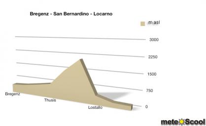
We make a journey from Lake Constance over the San Bernardino Pass to the Lake Maggiore. The places on this journey are Bregenz, Sargans, Chur, Thusis, Splügen, San Bernardino Pass, Lostallo, Bellinzona and Locarno. The elevation profile of the journey is shown in the diagram on the right, in m asl (meters above sea level).
Bregenz (427 m asl)
We start our little climate journey in Bregenz (Austria) at the Southeast bank of Lake Constance. Since we are in the temperate climate, the weather changes depending on seasons and current large-scale weather.
Sargans (480 m asl)
The Swiss municipality of Sargans is located approximately 60 km south of Bregenz and only slightly higher, with 480 meters above sea level. Therefore, the actual weather conditions are here usually very similar to Bregenz.
Chur (593 m asl)
Chur is located approx. 25 km south of and 100 m higher than Sargans. The temperatures are therefore often slightly lower.
Thusis (720 m asl)
Thusis is located further 130 meters above Chur and about 20 kilometres south. Here one can already clearly see the temperature difference to Bregenz - our starting point.
Splügen (1475 m asl)
Splügen is located only approx. 20 km south of Thusis, but the elevation is twice higher. Therefore, the temperatures decrease significantly.
San Bernardino (2065 m asl)
We have now reached the San Bernardino Pass, with 2'065 meters elevation the highest and also coldest point of our small climate journey. We travelled further 20 km from Splügen and the drop of temperature is very clear. From Sargans, we travelled approx. 85 kilometres, and tripled the altitude. Although the places are located not so far from each other and within the same climate zone, the variations in temperature can be large (see mountain-valley).
Lostallo (439 m asl)
Lostallo is located approximately 30 km south of the San Bernardino Pass at an elevation of only 439 meters. If there are no singificant differences of cloud cover or wind, the weather there is similar to Sargans - since both places are at similar altitude and in the same climate zone.
Bellinzona (226 m asl)
Bellinzona is located approximately 20 km southwest of Lostallo, at 226 meters above sea level. Thus, Bellinzona is so far the lowest place on our journey and has therefore the highest temperatures (except if there is a dense cloud cover or a cold downhill wind from the Gotthard mountains).
Locarno (195 m asl)
The popular resort Locarno is located besides the Lake Maggiore, 195 meters above sea level, 20 meters below Bellinzona. With the sunhine exposure and no wind, as well as in yearly average temperature, it is the warmest place of our journey.


