Mendoza - Aconcagua - Los Andes
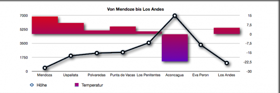
On the picture below, you see neighbour places with different heights which lead us on our path through the valley Mendoza, cross the mountain Aconcagua and ends in the valley of Los Andes. On the left part is the height represented. You can recognise the temperature with the red and blue charts.

The data for the diagram above are taken by the past meteograms. To get the up-to-date data a click on the respectively indicated meteogram is enough. While looking the tropical meteogram, the temperature is particularly interesting when compared with the height.
Mendoza (418 m asl)
Mendoza is the lowest place of this page with 418 meters. Compare the temperature of Mendoza with the other locations of this route. Mendoza should have the highest temperature. If not, check the precipitation and the cloudiness.
Uspallata (1933 m asl)
Uspallata ist with its 1933 meters over the ground much higher than Mendoza.
Look at the
temperature, it is lower than the temperature in Mendoza (also here: if not, check the precipitation and the
cloudiness).
Polvaredas (2268 m asl)
Polvaredas has almost the same height than Uspallata, therefore the difference in temperature is small, as you can see it.
Punta de Vacas (2374 m asl)
Punto de Vacas has almost the same height than Polvaredas. Therefore they have similar average temperature.
Aconcagua (6962 m asl)
The highest point of this mountain is at 6692 meters. The forecast is done for the highest point. This point is 4000 meter higher than Punte de Vacas. Here it must be very cold.
Eva Peron (3300 m asl)
Eva Peron is 1000 meter higher than Punta de Vacas - compared with it, it should be colder. But Eva Peron is under the summit of the mountain Aconcagua and it is thus warmer in Eva Peron than on the peak.
Los Andes (809 m asl)
Los Andes has again a lower height. Look at the temperature, here, it is again much warmer.


