
Fog
Fog

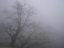
Fog in a valley of the Black Forest
The term "fog" describes visibility in a cloud which is in contact with the ground or sufficiently close to it. This kind of low level cloud is formed by condensation of supersaturated air, which usually happens when the air temperature drops and when there is extremely low or no wind blowing. A visibility of less than 1 km is thus defined as fog and a visibility higher than 1 km is called mist.
Origin and classification
Fog may build in different ways. A distinction is made in terms of development between radiation fog, advection fog, evaporative fog, orographic fog (or rising fog) and mixed fog. Sometimes, these forms appear in combinations.
Radiation fog
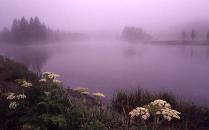
The radiation fog usually forms when the air is cooled to such an extent that the relative humidity reaches 100%, the saturation point. It usually forms during the night due to the heat irradiation from the surface of the Earth and the associated cooling of the lower air layer. It dissolves very quickly again in most of the mornings, thanks to the ground warming.
Advection fog
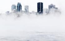
The advection fog occurs when warm air slides over colder air layers and is cooled. Advection fog usually occurs as heavy fog, during an inversion. This means that a warmer air layer has slidden over a colder layer, which does usually not occur. Between the two layers, a thick blanket of fog is then created. Advection fog is the longest lasting form of fog, and may persist over several days to weeks under certain circumstances.
Evaporation fog
Evaporation fog forms when the relative humidity is increased by the evaporation from soil, plants or water surfaces, while the air temperature remains constant.
Evaporation fog forms above very humid and warm surfaces. It will predominantly form over waters which are warm relative to the air temperature. In this case, the evaporation fog is also called steam fog (sea smoke).
Special cases of evaporation fog are the thaw fog and precipitation fog. Thaw fog appears when moderate warm air passes over frozen ground or snow, heats this surface layer and increases evaporation. The evaporating humidity may partly condensate again. Precipitation fog is formed when raindrops fall through warmer air layers and thereby evaporate.
Orographic fog
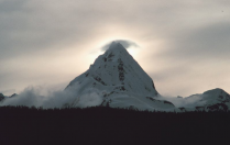
The orographic fog (or rising fog), also called mountain mist, is also a type of cooling fog. The air cooling occurs through decrease of air pressure if, because of wind streams, air masses passed over a mountain or on a mountain. The fog is visible as a cloud around the mountain peaks.
Mixing fog
With mixing fog, there is a simultaneous cooling and humidification of the air. This happens in a turbulent mixing of warm, moist and cold air. The differentiation from other forms of fog can be quite difficult, since mixing processes in the formation of fog almost always play a role.
Special case: ice fog
A special case related to the fog is the ice fog. This is not a fog in the strict sense, since
it is not formed by a condensation process. The water vapour contained in the air thereby passed directly from the
gas form into the solid state, without condensing before.
This fog only occurs when it is extremely cold.
Unlike normal fog, there are no fog water droplets, but ice crystals suspended in the air. Ice fog is therefore
defined as a separate species from the actual fog.
Forecast
Prediction of fog for a particular location is very difficult, because fog often occurs very locally. As well, the formation of fog depends on many different factors, so that the likelihood of fog formation can only be calculated from very high efforts and limited accuracy.
Composition: Linus Uhl, 2012.

