
Wind
Wind
The wind is the movement of the air.
For us, the wind could be:
- my cap's flown off;
- a nice breeze;
- the door slams;
- the one who threw over my bicycle;
- blowing my umbrella away;
- knocking over a tree.
The wind does also more than affecting us. The wind moves clouds whence they originate to the place where they drop precipitation, transports pollen from plants over many
kilometres or dust from deserts into neighbouring regions.
The wind also brings fresh air into polluted cities, carries dust and pollution over thousands of kilometres,
damages houses and roads sometimes and influences the air traffic every day.
The wind is the basis for
several human activities and sports. It moves sailing ships, balloons and gliders, is used by wind- and kitesurfers
and paragliders, and model plane enthusiasts. Surfers also depend on the wind; the waves they ride are caused by
winds.
Without wind, no weather would exist and our Earth would look virtually different.
Whence does the wind come?
What is the wind? The wind is - simply said - the movement of the air in the troposphere, the lowest layer of the terrestrial atmosphere. The wind develops in this "weather layer" due to the following characteristics of the air:
- The air consists of a gas mixture (nitrogen, oxygen and others).
- The air transmits heat badly, and thus releases it only slowly.
- The air is hardly heated by the sun rays.
- The air becomes thinner with altitude.
- The air can take up water vapour in larger quantities (on average about 1%).
The emergence of wind - i.e. air movement - occurs in the following (simplified) way:
- The surface of the Earth is heated by sun radiation - often by 10°C and more on a sunny day.
- The lower air layers are heated with contact from the ground and thereby expands.
- Warmer, thinner air now rises upward, displacing the cooler, heavier air above it.
- The "bubble" left by ascending air is filled by cooler, heavier air (which flows usually from sideways or from surrounding hills).
This process leads to the movement of larger air masses - and to wind. The wind originates from pressure differences.
Significance of the wind
You can see the same phenomenon when you light a candle. The air around the candle gets (extremely) hotter and flows up. If you put a little windmill over it (or some thin wires), their movement shows the up-flowing air.
In the atmosphere, these processes are spacious and much more gigantic. The moving power station, the Sun, is larger than the candle. The solar energy from the Sun arriving on the Earth, is five thousand times larger than the energy used by all human beings.
The wind arises in little scaled areas and in greater dimensions as well.
1. Local winds
The radiation of the Sun already warms the landscape at small scales. Let us study a building: The side of wall exposed to the Sun gets warmer than that of the shadow side. If one opens the windows of both sides, one gets wind shortly. Draughts develop because the colder (heavier) air flows from the shadow wall to the warmer (lighter) air of the sunny side of the wall. When the Sun keeps shining, this effect keeps developing, because the streaming cold air gets warm really fast and thus more cold air follows.
Further examples of local wind systems can be found easily. In each area, in which you can find a difference in temperature of more than 2°C, a flow of air can be measured. This means the top of a table or a street warmed by the Sun is enough for air movement to occur.
Stronger local air movements procreate themselves to "up-draught" in upper levels of the air. When you watch birds on a sunny day, like buzzards or hawks, you see them make circles to get more height and they turn around the centre of the ascendant current.
Local wind systems rarely get faster than 30-40 km/h. But when some local winds concentrate together, like close to thunderstorms, regional wind systems develop. Those are getting stronger and stronger, increase their speed and sometimes, under special conditions, become storms.
2. Regional winds
If differences in temperature occur in a permanent way, regional wind systems emerge and flow over several kilometres and may continue for days. They temporarily reach the highest wind speeds ever measured at the bottom. Those are not durable and because of this, they are sometimes also surprising. That is why they are the most dangerous systems.
Types of wind - examples
Foehn wind
Foehn is a special form of downslope, warm and drywind, which develops by the inflow of wet air on the windside of a mountain. The air is forced to elevate by the mountain while cooling down and losing a great part of its humidity. What results is a heavy, "monsoon-like" and torrential rain at the humid side of the mountain. As soon as the air has passed the ridge of the mountain, it flows downwards on the other side and is heating faster than the cooling on the humid side, as the air has lost its humidity while raising up. The resulting downslope is more arid, warmer and experiences stronger winds than its surroundings would have us believe.
Thunderstorms
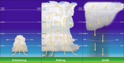
Clouds from thunderstorms develop because of the uplift of warm and wet air. Prerequisites are: (1) a wet air layer with a great enlargement near the bottom; (2) a distinct vertical drop of temperature and; (3) a trigger for the up-flow of wet air (lifting), so that an up-flow tube develops.
Because of the great difference in temperature, the wet and warm air flows up really fast and then cools down to a certain height (cloud ceiling) at which little drops arise. The uplift is getting stronger with great vertical differences in temperature and humidity. These steady winds increase up to 100 km/h, while they are close to be thunderstorms. In thunderstorms, winds reach velocities that are beyond 100km/h fast. When these differences are especially great, tornados arise and for which wind whirls reach velocities of over 500 km/h. These storms are able to destroy buildings.
Hurricanes
Hurricanes usually develop in tropical areas when a high insolation creates a large difference between temperatures and pressures. Especially above warm ocean surfaces, big masses of humid air raised by strong insolation, develop into great thunderstorms and consolidate into big cells. In the mid-latitudes (around the Tropics), such cells spin around a centre of low pressure (the "eye" of the storm). Under certain conditions, the twist becomes so strong that there can be over 150 km/h of wind velocity at the surrounding of the cells. The centre moves simultaneously and usually to the west and off-wards from the Equator. In this way, the hurricanes can expand over one hundred kilometres and can exist for weeks and destroy areas bigger than 1000 km². On land, they quickly lose their power and thus destructions concern almost exclusively the coasts.
The Jet Stream
Because of the great difference in temperature between the Poles and the Equator, there is a development of spacious wind systems that exist throughout longer times and above entire continents; which have a determining influence on the climate of the Earth.
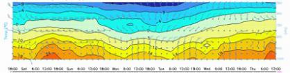
The "Jet Stream" is a wide belt of strong wind of one hundred kilometres in the upper boundary of the troposphere, and is formed as a consequence of a global compensation movement between different temperatures - resp. pressure regions. This belt is, like the trade winds, in its appearance very solid and stable. Within the Jet Stream there are the strongest natural winds, with wind velocities over 600 km/h. The Jet Stream is hard to quantify and it can just be illustrated and analysed by high weather cards. For example, you can see the bands of the Jet Stream on a card with high winds at 10 km in altitude (see world winds map at 10km height below).

In the following animation, the world map is regarded from rising air layers. How does the wind force change in the height?

The animation starts with low air layers and then increases the altitude. You can see that the wind speed increases with altitude, in particular in the area of the Jet Stream.

