Precipitation
Precipitation
In meteorology, precipitation is any product of the condensation of atmospheric water vapour, most often from clouds, that is pulled down by gravity and deposited on the surface of the Earth. The main forms of precipitation include rain, snow, ice pellets and graupel.
Rain
Rain is liquid precipitation (water droplets) and the most frequent type of precipitation on Earth.
Rain requires:
1. The presence of a thick layer of the atmosphere with temperatures above the melting point of water
near and above the surface of the Earth.
2. The condensation of atmospheric water vapour into drops of water,
heavy enough to fall, often making it at the surface.
Two processes, possibly acting together, can lead to the air becoming saturated and leading to rainfall: cooling the air or adding water vapour to the air.
Hail
Hail forms when the air is unstable, that is mainly in summer, and when thunderstorms occur.
There are strong vertical movements (convection) inside a cumulonimbus and the air becomes thus saturated in the
upper layers of the cloud. The water droplets are lifted then freeze while meeting a condensation nucleus and create
hailstones. These hailstones can become bigger when water droplets are supercooled, which can happen until -39°C,
and aggregate into existing hailstones.
While falling down, hailstones start to melt, as the air becomes
warmer. The hailstones we find on the ground are thus smaller than those in the cloud.
The affected areas by hail are usually small and the hail only falls for a short time. However,
if hailstones are big, damages can be consequent and expensive.
It is difficult to forecast hail early enough,
because there still does not exist any accurate way to measure hail storms and detect them.
Ice pellets
Ice pellets (US: sleet) are small hailstones with a diameter smaller than 5 mm. This kind of
precipitation, contrary to hail, occur mainly in winter when a warm air layer passes over a colder air layer with a
temperature smaller than or equal to 0°C.
In this case, like for hail, small hailstones form in a cumulonimbus
but do not become as big as real hailstones. Then, when the hailstones fall through the warm air layer, they melt or
partially melt and when arriving in the colder air layer near to the ground, they freeze again and form the ice
pellets.
Graupel
Between hail and snow you can find graupel with a diameter between 2 and 5 mm. This type of
precipitation also forms in cumulonimbus, but the ascending currents are weaker than for hail. Inside of the cloud,
supercooled droplets aggregate to snow crystals; this process is named “accretion”. Graupel mainly occurs just
before snow falls and seems to be rime droplets.
Contrary to the snow, graupel grains break easily. They often
bounce off the ground and break.
Snow
Snow is a type of precipitation within the Earth's atmosphere in the form of crystalline water
ice, consisting of a multitude of snowflakes that fall from the clouds.
The ice crystals, less than 0.1 mm,
developing thereby, fall by increasing weight and continue to increase by the difference of vapour pressure between
ice and undercooled water. As well, water vapour contained in the air re-sublimates (from the solid phase to the
gaseous phase), thus transforming directly into ice and thereby contributing to the crystal growth.
Snowfall
amount and its related liquid equivalent precipitation amount are determined using a variety of different rain
gauges. As a rule of thumb, 10 cm of snowfall corresponds to 1 cm of water.
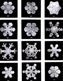
Snowflakes fall in a variety of sizes and shapes. They are hexagonal and because of the special
structure of water molecules, only an angle of 60° and/or 120° is possible.
Every snowflake is different -
there are no identical shapes.
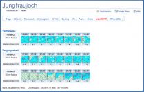
Jungfraujoch
On the Snow meteogramme on the right, you see the current weather forecast for the area of the Jungfraujoch (Switzerland). The average elevation of the area is 2826 m asl (metres above sea level). The graphic shows the predicted temperature gradient for different elevations. The lower part of the graphic shows the predicted total precipitation, the snow height and the change (increase or decrease) of the snow height.
Forecast
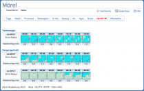
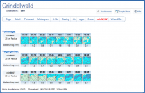
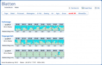
In the following, you can see the RainNow forecasts for four different locations on the
29.07.2010. They show precipitation every 15 minutes for the last two hours and the subsequent hours. Now take a
look at the forecast of the Jungfraujoch and memorise the position of the precipitation areas (dark coloured areas).
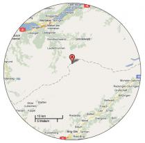
Take a look on the card. Here, the Mountain Jungfraujoch is in the centre (A). This card shows - like the
RainNow forecast of the Jungfraujoch - the surroundings at 25 km distance.
Name the locations, where it
shall/has already rained. Now compare the forecasts with the RainNow forecasts of the surrounding locations for
which there are also RainNow forecasts.
Example: The RainNow forecast of the Jungfraujoch says that there will
be showers as from 07:00, but not before that (there are blue areas as from 07:00 o'clock).
Now, we take a look
at the card (right hand side). Mörel is a location in the South. Now take a look at the RainNow forecast of Mörel.
Mörel is in the centre of the square area. So the centre has to be coloured in blue since 07:00. Before, it did not
rain in Mörel. So, the centre must not be coloured in blue until 07:00. In this way you can see in which locality it
will rain or not.
RainNow forecast of the 29.07.2010:
Jungfraujoch
Grindelwald
Blatten
Mörel