
Atmospheric circulation
Atmospheric circulation

Atmospheric circulation cells and global windsystems
On Earth, an atmospheric circulation takes place (see picture) which is triggered by the temperature difference on the ground at the equator and poles. The
sun virtually perpendicular trajectory over the equator produces much more heat in that area, then the shallow angle
the sun trajectory follows relative to the Earth's poles.
During the year, the sun changes it's noon-time
angle from perpendicular over the Northern (Cancer) tropic to perpendicular over the Southern (Capricorn) tropic.
The change in angle leads to stronger insolation on the Northern Hemisphere from April to September, and stronger
insolation on the Southern Hemisphere from Octobber to March.
Thus, different pressure areas which trigger a large circulation between the equator
and the poles are formed. Because of the Earth´s rotation, a direct flow between anticyclone (equator) and depression (poles) is prevented. In the Northern
hemisphere, the air masses are deflected to the right and in the Southern hemisphere to the left. For that reason,
three large circulation cells are generated (Hadley cell, Ferrel cell and the Polar cell).
The main effects of the atmospheric circulation:
- Continuous transport of humidity from the equator to the North and to the South tropics.
- Transport of hot air and humidity from the tropics to the temperate zones.
- Transport of warmer air and humidity from the temperate to the colder zones.
Hadley cell

At the equator, the air rises up, because of strong heating by the sun. At the tropopause (temperature inversion in about 18km above ground), the air masses will deflect to the North and South. Through area correction, the air masses slide down to the poles. Furthermore, through the earth´s rotation, the winds fall until the 30th latitude and flow back to the equator as trade winds. At the equator, these winds meet in the Intertropical Convergence Zone (ITCZ). This circulation is called Hadley cell.
During the ascend process, the air cools down, the humidity inside condenses, clouds are build and it starts to rain very strongly. In the descending process, the exact opposite is happening. The air warms and the water in it starts to evaporate. Desert areas (such as Sahara or Namib Desert) around the 30th latitude are consequences of this process. There are several anticyclones in this region, which is caused by the warm air on the ground. These are assigned to the subtropical ridge (horse latitudes).
Polar cell
Near the ground level, air currents flow from the poles toward the equator. These are called polar easterlies, because they are distracted from eastside by the rotation of the earth. Near the 60th latitude, the winds are heated and rise up on the way to the South. This second circulation is called Polar cell.
Ferrel Cell
Based on air ascent (60th latitude) and air cooling (30th latitude), a third circulation is formed in the area between the 60th and 30th latitude. This circulation is called Ferrel cell. Near ground level, there is an air transport towards the poles wherey the air flows towards the equator at higher levels. In the northern hemisphere, the air on the ground is distracted to the right and in the southern hemisphere to the left. The winds from the West are called westerlies.
The polar front is located on the border between the polar easterlies (cold) and the easterlies (warm). This border is usually between the 60th and the 70th latitude. In this area, depressions often occure.
Exercises
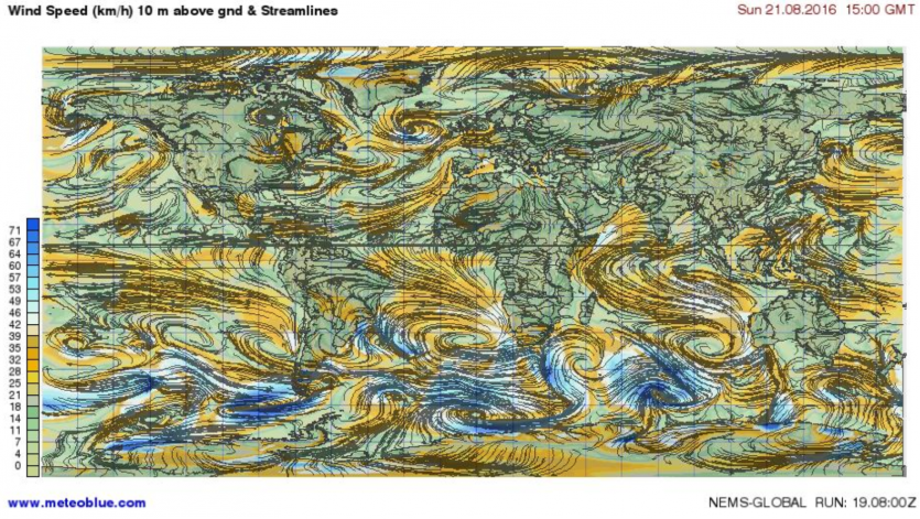
The map below shows the prevailing winds on a high of 10 meters above ground.
Exercise 1: Try to identify the following wind currents on the map.
- North- East trade wind
- South- West trade wind
- Westerlies
- Polar easterlies
Exercise 2: Try to identify the following anticyclones and depressions on the map.
- Intertropical convergence zone (ITCZ)
- Subtropical ridge
- Polar front
Exercise 3: Compare the different wind currents above the country (continent) and water (ocean). What are possible reasons for your findings?
Publisher: J. Schweizer

