
Warm front
Warm front
A warm front is defined as the leading-edge of a warm air mass, which moves forward as a "front", slides upon a colder air mass and replaces it by driving out the "cold" (else: by warming the cold air below, mostly through precipitation), as it passes.
Contrary to the cold front, the border between the two air masses is less visible, as it extends over a larger distance.
Origin of a warm front
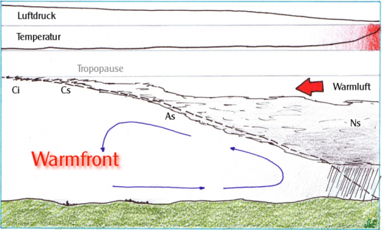
The origin of a warm front is caused by the tropical air meeting colder polar air. With the warm front coming, the atmospheric pressure decreases while the temperature increases, because of the warm air having a lower density. The warm front has an more extended slope than the cold front and thus leads to different types of clouds and amount of precipitation. Some layer clouds, like cirrus or stratus, usually appear above the warm front.
The warm front moves slower than the cold front; that sometimes leads to an occlusion, when a cold front catches up with the warm front and the energy of both fronts adds up. The warm air is then pushed up and a strong depression (low pressure) forms just before.

