Monitoring system & Process
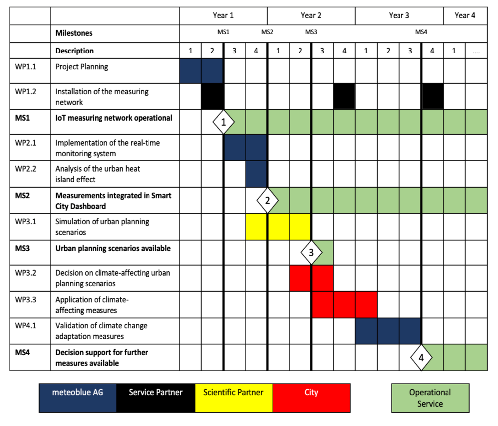
The meteoblue city climate monitoring system consists of four different modules and can be made fully operational within less than 1 year. The system is designed in such a way that the services developed for the city can be continued sustainably over a project period of 1-3 (or more) years. Depending on the use case of the customer, each module can also be implemented separately. After the successful completion of the modules, the following goals will be achieved:
- IoT measurement network is successfully installed and fully operational
- Measurement data, heat maps and further analyses are integrated into an already existing smart city dashboard, and available to all stakeholders in real time
- A catalogue of different urban planning scenarios is available to all stakeholders, offering a solid scientific basis for climate change adaptation measures
- We offer further support for decision-making regarding follow-up measures
Setup
In the first phase, a fully automated IoT measurement network is installed in urban areas (as well as in the surrounding rural areas), measuring air temperature and precipitation at typically ≥50 different locations selected according to scientific criteria. The aim is to cover all local climate zones and points of interest, in places where the (often costly) official WMO-certified stations cannot operate due to technical restrictions. Alternatively, data from existing measurement systems can be integrated into the processing chain.
Operation
In the second phase, a real-time monitoring system is utilised, which shows calibrated and quality-controlled measurements, and utilises satellite data and external models to generate special city climate maps (e.g., heat maps which detect and visualise the urban heat island effect at the spatial resolution of 10 m, cold air flow maps, or precipitation risk maps). The real-time monitoring system can optionally be integrated into existing city management platforms.
Planning
In the third phase, a surface energy balance model is applied to possible options for climate change adaptation measures (e.g., roof greening, irrigation, de-sealing of surfaces) for urban hot-spots, to select the best adaptation strategy in the city. Additionally, measures already planned can be prioritised, and the economic effectiveness can be assessed.
Validation
The fourth phase analyses the climate impact of the climate change adaptation measures by using the IoT measurement network, and comparing locations where adaptation measures have been implemented to those where no adjustment took place.
meteoblue works with station suppliers, local service providers, and our scientific partners to ensure the best possible quality, and to achieve all relevant milestones in due time. Each project is designed in such a way that the services developed for the city can be continued sustainably after reaching the milestones at the end of each project phase. Optimally, the first three phases are completed within 1.5 years, and thereby assist the city authorities in preparing for climate change.
The following table provides an overview of the various phases, and offers an estimate of the approximate time required to reach the milestones.