
Specifications

Transmission
meteoblue offers a wide range of data packages, images and weather maps that can be delivered through different transmission means.
Weather variables
Various weather variables are displayed by meteoblue in different forms like meteograms or pictograms. They all are indicators that will help you to understand the weather.


Spatial dimensions
meteoblue provides different levels of weather information, which can be visualised in charts or obtained as data. These show weather information from the local point to continents and from surface to atmosphere.
Data sources
The data used by meteoblue originates from various weather services and sources. Initial conditions are usually determined through the help of measurements, which cover some of the most important locations and weather variables, but describe only a fraction of the surface of the Earth and weather processes.

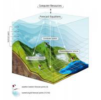
Weather model theory
meteoblue weather models are based on the NMM (Nonhydrostatic Meso-Scale Modelling) technology. Model calculations are done for large domains, which are in turn embedded in larger scale global models (such as NEMS30), which provide the boundary conditions.
