
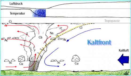
Cold front
Cold front

Arrival of a cold front
Picture: meteoblue
A cold front is defined as the leading-edge of a cooler mass of air, which moves forward as a "front" and replaces a warmer mass of air (at ground level) by lifting it as it passes.
When arriving, a cold front looks like a roll of dark, low hanging clouds, usually moving
forward at speeds of 30 to 80 km/h. When it arrives, the sky is rapidly covered and the sunlight is considerably
reduced to the point that lights have to be turned on in buildings.
How does a cold front develop and how does
it affect the weather?
Origin of a cold front
A cold front originates between the centers of high and low pressure. Pressure differences
cause the flow of air from the center of high to the center of low pressure. Typically colder air from the center of
high pressure flows towards the center of low pressure, where the warm air rises.
With larger pressure
differences, the speed and amount of air flow increases. Thereby, larger amounts of cold air are put into motion and
aggregate into a large front of several hundred kilometres of width. This front is further compressed by the cold
air following the first front.
Cold fronts move ahead rather fast and raise the warm air in front of them.
Under certain conditions, however, the cold air can also float over the warmer air ahead and further mix and cool it
down subsequently.
Cold fronts usually cause precipitation, because they cool the air to the point where the
contained humidity condensates.

