
Temperature
Air temperature
Air temperature is the weather characteristic that we most directly feel.
Warm - cold;
fresh - heavy; hot - icy: that is how we feel the temperature of the surrounding.
Temperature in altitude
All materials consist of many small particles, called molecules: the air, the earth, everything that surrounds us. The state of aggregation of a material - solid, liquid or gaseous - depends upon how closely these molecules are bound together. Take the example of water. Water freezes below 0°C and becomes thus solid. Molecules move closer and connect together. Starting from a temperature of 0°C (fusion point) to 100°C (boiling point), water is liquid. Water molecules are in a somewhat loose grouping and move relatively towards one another. Starting from the boiling point, water evaporates and becomes gaseous. Molecules are now far apart from each other and have essentially no more cohesion. They move faster than in a liquid or solid state. This condition requires more energy. One also calls this "heat energy", which we measure from temperature.
As previously mentioned, this change in state of material modifies the density and depends on
"the tightness" with which molecules reamain and bind together. Solid bodies have thus a higher density than gaseous
materials, because their molecules stay more closely together. In the atmosphere, most molecules are in the form of air. The air
protects the Earth from the Sun and from space.
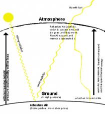
In the accompanying
pictures, one can see how the sunlight passes through the atmosphere
and reaches the surface of the Earth. The molecules of the ozone layer filter part of the sunlight, which therefore
does not arrive on the surface of the Earth. However, most of the sunlight reaches the ground, as the density of the
air being small.
On the surface of the Earth, the sunlight is, to a large extent, absorbed by the ground. Thus,
the ground heats. A smaller part of the sunlight is reflected again into the atmosphere.
The air at the surface level is now heated by the ground. Since the air molecules move apart
when heating, air expands and loses density - heated air rises. As the pressure at the ground is higher than in the atmosphere, ascending
air can expand further with altitude. During this expansion, heat energy is lost and ascending warm air cools down.
It hardly continues to warm up due to the increased distance to the ground.
As well, the reflected and
partially long-wave radiation has less energy and does not heat the air as much as the incoming radiation.
Furthermore, the air contains fewer molecules by volume, which could be met by the sunlight, due to the expansion.
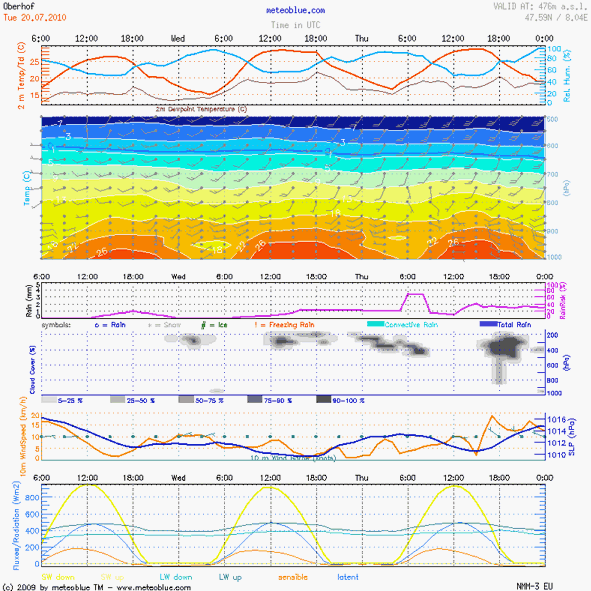
Therefore, lower temperatures prevail in the higher layers of the air (see the animated AIR meteogramme on
the right).
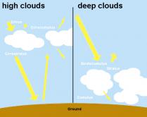
If it is cloudy, water molecules in the cloud absorb a
large part of the sunlight. Only a small part of the sunlight eventually reaches the ground. Therefore, it is often
cool below the clouds, even with high sun radiation.
Air rising by high temperature
If the sun radiation is very strong, air warms up more rapidly at the ground and rises. It
displaces the cooler air from higher layers and expands at the same time, as the air pressure decreases with
altitude. The rising of the air temperature and the warming of the higher atmosphere layers during the day is shown
in the animated AIR meteogramme on the right.
If more and more air warms up and rises, a kind of "air bubble"
develops, which can expand the whole troposphere (lower layer of the atmosphere) upwards. This is one of the reasons
why the troposphere is thicker in the Tropics than
in the polar zones.
Temperature inversion
An inversion is a situation, in which the air temperature is warmer in the higher layers than
in lower layers of the atmosphere.
This is caused by the process of heating. The hot air rises and then stays
above the cool air. For an inversion to happen, something must either prevent the heated air from cooling when it is
in a higher layer, or something must cool the air below more rapidly than the air above. Causes for such an inversion can be:
- Subsidence: Cold air flow towards lower areas from surroundings (e.g. mountains, glaciers): The cold air displaces and elevates the warmer air. A continuous inflow of cold air keeps temperatures at the ground lower than above it.
- A warmer air mass moving over a cooler mass, also known as a capping inversion. This layering may be less stable, and can broken, either by extreme convection overcoming the cap or by the lifting effect of a front or a mountain range, the sudden release of accumulated convective energy—like the bursting of a balloon—can result in severe thunderstorms.
- Weak solar radiation. This situation occurs mainly in winter, when the ground has cooled for some time and the air near the ground can no longer warm up, or also under a thin layer of low clouds, that prevents sunlight from reaching the ground and warming it up.
Examples of an inversion due to cold air flow can be seen on the AIR meteogramme (on the right). The flow of cold air from nearby mountains creates a cold air cushion above the bottom of the valley at 970 metres (green bar) on about 2000 metres in altitude above the surrounding terrain (brown line).

