Measure urban climate where it matters with modern IoT technology
The meteoblue City Climate Monitoring system consists of four different modules and can be made fully operational within less than 1 year. The system is designed in such a way that the services developed for the city can be continued sustainably over a project period of 1-3 (or more) years. Depending on the use case of the customer, each module can also be implemented separately. After the successful completion of the modules, the following goals will be achieved:
- IoT measurement network is successfully installed and fully operational
- Measurement data, heat maps and further analyses are integrated into an already existing smart city dashboard, and available to all stakeholders in real time
- A catalogue of different urban planning scenarios is available to all stakeholders, offering a solid scientific basis for climate change adaptation measures
- We offer further support for decision-making regarding follow-up measures
Please contact us for more information on the implementation of a City Climate measurement network in your city.
Urban Climate Challenges
The world's population living in urban areas is more than half today, and constantly rising. The increasing number of people in cities also require more living space and extended infrastructure. With increasing infrastructure density, further temperature increases are likely or need compensation measures even in cities where this is not yet necessary. Extensive monitoring of the urban climate is the basis for significantly improving the quality of life by evaluating suitable urban measures.
Municipal companies can improve their efficiency (traffic, road and construction management, water budgets, etc.) if they have access to close-meshed (temperature, precipitation, etc.) measurements in the city. Organisers, planners, and insurance companies can benefit from better risk assessment for heat, precipitation, wind and other factors.
Dr. Sebastian Schlögl, Head of Climate Services at meteoblue, speaks about challenges arising from climate change, and the ability to monitor and mitigate associated risks.
Cities with active City Climate Monitoring Systems
This project has received funding from European Union's "Horizon 2020 Research and Innovation Programme" under the Grant Agreement 101004112.

Realtime Connect
To get an idea of what a measurement network looks like and how we display and use such data, you can explore real-time measurements in Basel, Switzerland, established in 2020 and consisting of more than 180 Metos LoRain sensors. In principle, the sensors were distributed throughout the city centre and in the outskirts and suburbs of Basel in order to cover all relevant local climate zones.
Air temperature, precipitation and relative humidity are measured in 15-minute resolution. Transmission is secured by the IWB's LoRa network. The map view makes it effortless to see large-scale patterns of temperature or precipitation over the urban area (figure on the left). Hotspots can be detected visually.
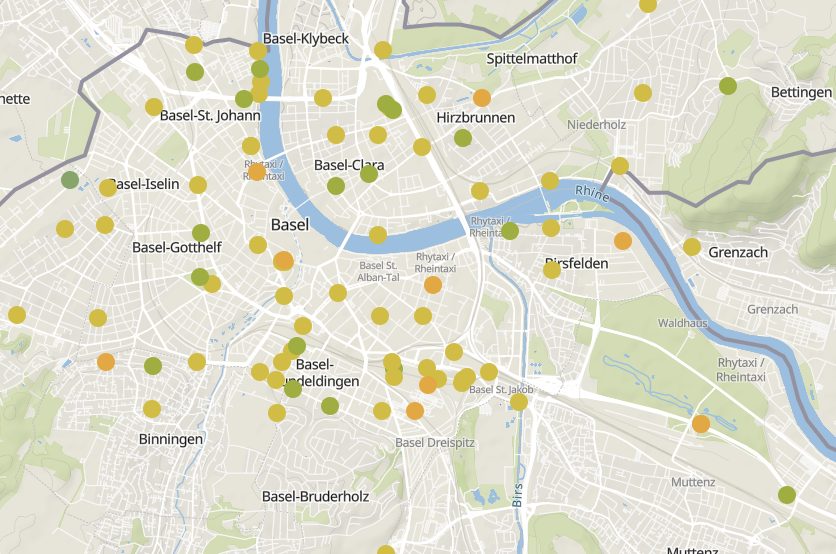
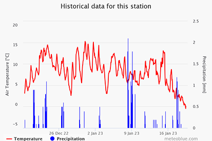
In addition to the raw data, a range of other information is offered. These can also be accessed by clicking on a station on the map (see figure on the right above). Historical measurement data in graphical form, a 5-day forecast based on station data, and statistical evaluations are available on the meteoblue website. The statistical analysis includes e.g., the average air temperature and precipitation sum in daily, weekly, and monthly resolutions.
Heat ranking compares the average air temperatures of all measuring stations and assigns them a number in the ranking. This helps to quickly identify hotspots in the city.
In addition, meteoblue offers a raw data API, with which one can secure access to the complete time series of all urban climate data since the installation in 2020.
Monitoring System & Process
1. Setup
In the first phase, a fully automated IoT measurement network is installed in urban areas (as well as in the surrounding rural areas), measuring air temperature and precipitation at typically ≥50 different locations selected according to scientific criteria. The aim is to cover all local climate zones and points of interest, in places where the (often costly) official WMO-certified stations cannot operate due to technical restrictions. Alternatively, data from existing measurement systems can be integrated into the processing chain.
2. Operation
In the second phase, a real-time monitoring system is utilised, which shows calibrated and quality-controlled measurements, and utilises satellite data and external models to generate special city climate maps (e.g., heat maps which detect and visualise the urban heat island effect at the spatial resolution of 10 m, cold air flow maps, or precipitation risk maps). The real-time monitoring system can optionally be integrated into existing city management platforms.
3. Planning
In the third phase, a surface energy balance model is applied to possible options for climate change adaptation measures (e.g., roof greening, irrigation, de-sealing of surfaces) for urban hot-spots, to select the best adaptation strategy in the city. Additionally, measures already planned can be prioritised, and the economic effectiveness can be assessed.
4. Validation
The fourth phase analyses the climate impact of the climate change adaptation measures by using the IoT measurement network, and comparing locations where adaptation measures have been implemented to those where no adjustment took place.
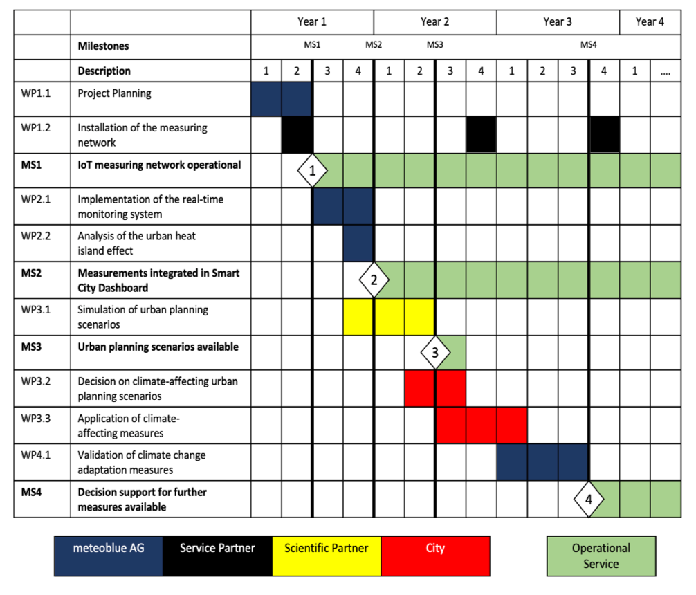
meteoblue works with station suppliers, local service providers, and our scientific partners to ensure the best possible quality, and to achieve all relevant milestones in due time. Each project is designed in such a way that the services developed for the city can be continued sustainably after reaching the milestones at the end of each project phase. Optimally, the first three phases are completed within 1.5 years, and thereby assist the city authorities in preparing for climate change.
The following table provides an overview of the various phases, and offers an estimate of the approximate time required to reach the milestones.
Measurement quality assurance prepares the raw data for further analysis. Data filtering, gap filling, and homogenisation add significant value to raw measurement data.
meteoblue provides measurement quality assurance based on the measurements available via the API. meteoblue distinguishes between three different use cases: single station, multiple stations and city network. The quality assurance is provided for the following weather variables:
- Air temperature
- Precipitation
- Wind speed
- Wind direction
- Solar radiation
- Relative humidity
The measurement quality assurance allows for the tracking of data transmission through real-time alerts in case the stations are not sending information. Moreover, we create monthly reports and meteorological statistics for climate indices and station coverage. In addition, the system provides data normalisation in equally distributed timestamps, and offers functions such as station quality control, gap filling, and data homogenisation. The availability of these functions depends on the use case and the meteorological variable.
Different station providers can record the measurements with different temporal resolution. To compare the measurements of different station providers, it is necessary to compare the same timestamp. Additionally, the stations typically do not record exactly during the full or half hour. Therefore, the timestamping tool interpolates towards the full and half hours. The user can decide on the temporal resolution of the dataset. If the selected temporal resolution is smaller than the temporal resolution of the station provider, the values in between the regular temporal resolution are filled with NaN (Not a Number).
Station Quality Control
Quality control is conducted as a three-step process:
Screening
Metadata of the stations are checked for correctness. If the latitude or longitude of the station is located outside the natural coordinates of the Earth, the station data is submitted to a correction process. Additionally, the data coverage is calculated, based on the ratio of the relevant values (i.e., those which are not equal to NaN).
Static quality control for each station separately
Several different filters are applied to the time series of the individual station. These filters are typically different for different variables.
| QC1 filter for temperature | Description |
|---|---|
| NaN check | Detect NaNs |
| Logical check | Detect illogical values that are too high or too low |
| Static check | Detect outliers outside of thresholds |
| Flatliner check | Detect flatliners where consecutive values are the same |
| Blip check | Detect sudden temperature changes above threshold |
| Spatial check | Detect spatial illogical values |
Dynamic Quality Control
Dynamic quality control is used for complex comparisons between different stations (only applies for the use case of city network, see above). The spatial consistency of the stations is verified by applying neighbouring checks, and comparing stations within a specified radius around the station.
Gap Filling
Three different approaches are utilised for the gap filling.
- Linear interpolation
- If the gap is only one timestamp
- Use another station
- If the gap is larger than one timestep
- Find the station with the best correlation based on historical measurements
- Use the best correlated station and apply bias correction (to account for a potential bias between the two stations)
- Use model data
- If the gap is larger than one timestep
- Use model data from the meteoblue model chain which best fits the station (selection of up to 20 different numerical weather prediction (NWP) models depending on the location)
Data Homogenisation
The meteoblue data homogenisation tool contains several functionalities for a variety of use cases.
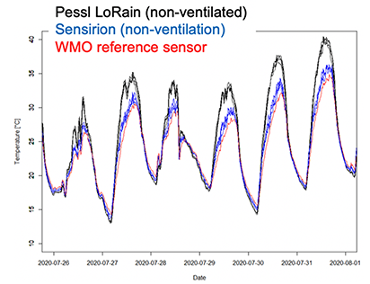
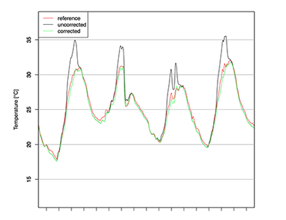
For temperature measurements, two different approaches (bias correction and radiation correction) complement each other and are available based on different assumptions. In case a low-budget city sensor network is used, a bias correction can be applied in the operational and historical use case if at least one low-budget sensor is installed close to a standard WMO station (e.g., METAR, MeteoSwiss, etc.). The bias correction calculates in real-time the difference between the low-budget sensor and the WMO station, and corrects this difference for all the sensors in the city network with an update frequency of the WMO measurement. This bias correction is applied to all variables available in the city network. This method accounts for systemic discrepancies between the WMO station and the city network, e.g., errors due to heat accumulation or systematic errors occurring during nights.
For the use case “historical city network” a scientific radiation correction is applied to ensure the best possible quality of historical weather data. Note that due to the complexity of this radiation correction, it is not possible to provide this method in operational usage.
Therefore, results in operation differ from results in the historical data package, where typically the highest quality is reached.
The scientific radiation correction is based on our special routines published in a scientific research paper, and includes separate corrections for shaded and sunny conditions. Direct shortwave radiation, diffuse shortwave radiation, air temperature, wind speed, and the solar elevation angle are used as input variables for the radiation correction.

If you have any questions or need advice, please get in touch. Our City Climate expert will provide you with the guidance and support you require.
Nico Bader
Meteorological Expert


