Precipitation
What is precipitation?
Precipitation is defined as a liquid or solid product of condensed water vapor that falls from clouds or is deposited from the air onto the ground. This includes rain, snow, hail, dew, etc. The total quantity and intensity are measured, which are given in the following units:
Total quantity:
- height of water column (mm)
Intensity:
- millimeters per hour (mm/h)
How is precipitation measured?
The amount of precipitation is always measured in a collecting tank called pluviometer. This can either be an automatic device that sends the measured values as a digital signal or the measurement is performed manually, which means that a human has to read the quantity. There are mainly two types of pluviometers that measure either water volume or weight.
Depending on the type of device, the measurement interval may be a few seconds to several days. This has a huge impact on accuracy.
The precipitation intensity can be directly output by automated measuring instruments. It is usually measured at intervals of 10 seconds and averaged over a minute. Such modern gauges are able to map the strong temporal variability of precipitation.
How should a pluviometer be set up?
Pluviometers have no clear WMO standard (World Meteorological Organization). However, in most countries the instruments are installed between 0.5 and 1.5m above the ground. In addition, the instruments must be processed in such a way that as little water as possible can splash out, adhere to the edges or splash from the ground into the device. In addition, it is advisable to avoid any obstacles in the environment, as these may, on the one hand, intercept precipitation, and may, on the other, cause turbulence in the air, which also affects the precipitation measurement. This also applies to stations with multiple measuring devices since these instruments may catch some of the precipitation and throw a "shadow" on the pluviometer. It is therefore advisable to install the pluviometers away from the other measuring devices. For very exposed places there are pluviometers with wind shields to minimise the turbulence caused by the device itself.
Which measuring instruments are most commonly used?
National weather services such as MeteoSwiss usually use one of two types of devices to measure precipitation:
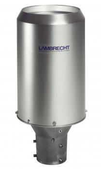
- A pluviometer with tilting system and heating for snowmelt, for example the device Lambrecht 15188 (Figure 1)
- A pluviometer based on the weighing principle, which is also heated depending on the climatic conditions, for example the Ott Pluvio2 (Figure 2)
The latter devices are more accurate, but they require a greater maintenance effort and are therefore not suitable for remote locations.
Which other measuring methods are available?
The easiest way to measure precipitation is to put a measuring tank with a scale into the open air and manually read the amount after the precipitation event. However, such a method is very error-prone and requires a high level of personnel.
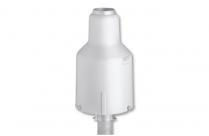
Figure 2: Pluviometer with a weighing sensor
In meteorology, the variants presented above are most commonly used. Measuring instruments with tilting system have a collecting container which tilts when water reaches a certain level and thus empties itself. Each tilting movement triggers a signal that is detected by a computer that calculates the intensity and the total amount.
Another method of measurement is to weigh the precipitation, which allows a very accurate calculation of the amount. In addition, this method can be used to create a continuous high-resolution time series that represent both the amount and intensity of the precipitation. The only disadvantage of these sensors is that the collecting container - at least for older models - must be emptied by hand.
In addition, there are laser-optical distrometers, which use laser beams to measure the size and velocity of each drop / snowflake, thereby calculating rainfall, intensity and the resulting visibility. However, in termes of accuracy, especially in measuring precipitation intensity, these devices are less performant.
Difficulties of precipitation measurement
In contrast to temperature, the spatial variability of precipitation is significantly higher. While the temperature between two weather stations in flat terrain behaves almost linearly and can therefore easily be interpolated, this is very difficult for precipitation. This is because precipitation events, in particular thunderstorms, can occur on very small spatial scales.
Furthermore, precipitation measurements are very error-prone. A large part of the errors is location-dependent, because even small obstacles, such as a tree or a power line, can influence the measurement result by absorbing part of the precipitation. With strong winds, this effect is amplified, since also obstacles at greater distances may influence precipitation through air turbulence.
In addition, splashes from other objects in the vicinity of a pluviometer can get into the collection container and thus impact the measurement.
Another problem is the contamination of the container by other objects. Especially in autumn, many leaves are transported through the air and can settle in the opening of the pluviometer. Also other objects such as branches, dust or sand can accumulate and pollute the measuring container.
In places with snowfall, the instruments must be heated so that the snow can neither fill nor cover the container and can be measured as a liquid precipitate. It is important that the heating is constant, as the volume of water is temperature dependent.
Another source of error is the evaporation of water by solar radiation. To prevent this, the equipment should include a funnel, which captures the water and leads it back into the measuring tank underneath. A narrow funnel opening minimises errors due to evaporation losses.
How many measuring stations are there?
MeteoSwiss operates more than 400 weather stations that measure precipitation. These are supplemented by a network of about 300 private stations, since precipitation is a very local phenomenon.
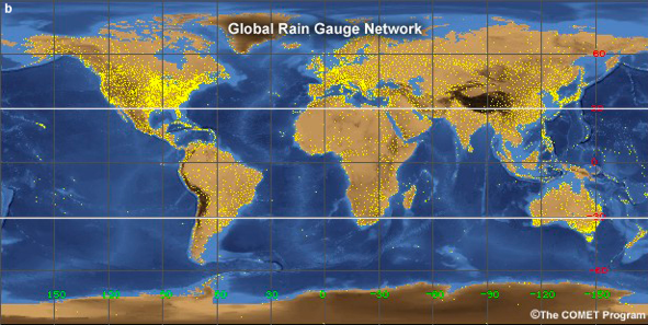
Figure 3: Global network of precipitation measurement
The Global Precipitation Climatology Center (GPCC), which is operated by the DWD (German Weather Service) on behalf of the WMO, collects quality-controlled data from more than 50,000 precipitation measuring stations worldwide. The time series of these measurements often have very large gaps and are error-prone despite quality control, which is why an automated use of this data is not suggested and a renewed quality inspection is recommended for validations.

