
Trajectories
meteoblue Trajectories show the simulated
air movement (wind) from or to the location selected in the
Global Location Search throughout the following
hours.
Multiple trajectories for a selection of different altitude levels ranging from the surface to 150
hPa (i.e. a height of approximately 10 km) can be generated and displayed on the same map.
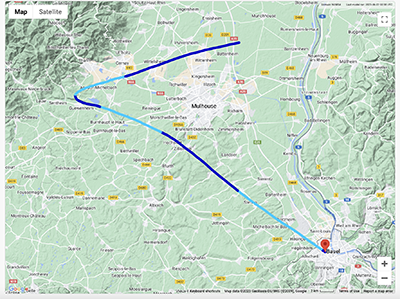
The chosen trajectory routes are shown on a map with the selected location marked by an indicator. The alternating colours on the trajectory represent an hour of travel time per segment. Moving the mouse cursor over a point on the route will reveal the geographic coordinates of that location, as well as the temporal distance to the target and the time at which it will be reached.
The top-right corner of the map provides information on the model domain used and the time of the most recent model run. The buttons in the top-left corner allow switching the background between the map and a satellite-image of the terrain.
Use recommendation
meteoblue air Trajectories can be used for many purposes:
- balloon flights
- airplane and glider flight planning, to anticipate (head)winds
- pollution tracking: where are emissions going?
- anticipating pollen flight
- understanding movement of air currents in the higher levels
- tracking storms
Usage instructions
If not already done, open the Trajectory page and select a place in the Global Location Search.
Initially, a trajectory will be displayed using the default settings:
- level = surface
- starting time = 0
- duration = 6 hours
Select the levels (hPa), starting time and/or duration as per your preferences and choose “Forwards” to generate the expected trajectory starting from your chosen location, or “Backwards” to find out which starting location would cause the trajectory to terminate at this location.
meteoblue air Trajectories may take some seconds to calculate and transmit, due to the large amount of data
required. If the image does not appear within 5 seconds, refresh the screen to repeat the query.
If you select a longer duration (more than 60 hours), the trajectory may be cut on the edge of the selected model
domain.
To be sure that all selected hours are included, try the query with a trajectory for 24 or fewer hours first, then
increase gradually.
If the sum of starting time and duration is longer than the available forecast period, no data will be displayed.
Check the available forecast period (e.g. using a meteogram)
and adjust the query starting time or duration.
For technical reasons, all trajectory queries are limited to 72 hours for the time being (sum of starting time and
duration).
Pressure and altitude
A conversion of pressure levels to altitude is shown on the page position.
Purchase
meteoblue Trajectories are available worldwide via point+.

