
Thunderstorms
Thunderstorms

Thuderstorm and ligthnings
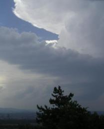
A lightning, roaring thunder, heavy rain and sometimes hail (or snow) - that's a
thunderstorm. One of the most impressive weather phenomena. In total, about 1600 thunderstorms occur
simultaneously on Earth, covering about 0.3% of the Earth's surface.
Who
doesn't know them? And who knows how they originate?
A thunderstorm, also known as an electrical storm, a lightning storm, thundershower or simply a
storm is a form of weather characterised by the presence of lightning and its acoustic effect on the Earth's
atmosphere known as thunder. The meteorologically-assigned cloud type associated with the thunderstorm is the
cumulonimbus. Thunderstorms are usually accompanied by strong winds, heavy rain and sometimes snow, hail, or no
precipitation at all.
Lightnings result from different electrical loads in clouds and Earth. That was already proven in 1752 by the researcher and
statesman Benjamin Franklin, by letting kites rise into thunderstorms. With these dangerous experiments, he also
invented the lightning rod.
In a thunderstorm, the temporary separation of electrical load develops if ice and
water particles - which load themselves differently with electrical load - are blown at different heights by strong
winds within high thunderclouds. Lightning is the sudden transmission of a larger electrical load released thereby.
Lightnings predominantly develop from there within thunderclouds. On the Earth, there are 40 to 50 lightning flashes
per second, and 10% of these lightnings reach the ground.
Thunderclouds result from the lift of warm and damp
air. The following three conditions are necessary for a thunderstorm to develop:
- Dampness: a moist air layer at ground level with a larger extension and relative humidity above 80%;
- Unstable layering: a clear vertical drop of temperature (temperature decreases with the height by more than 6.5°C per kilometre altitude);
- Elevation: A trigger for the rise of the moist air; this can be caused by strong sun radiation, slope upwinds or differences in the air layering.
If a moist pack of air starts to ascend from the ground by elevation, then it cools down by
around approximately 6.5°C/km (moist adiabatic ascent) during the ascent. Starting from a certain altitude
(condensation level = cloud base), water droplets originate (see cloud
formation) by condensation, due to the cooling of the air. By the condensation heat (energy which is set
free with the formation of water), the ascending pack of air cools down less fast than the surrounding air; thus, it
stays warmer and lighter (due to the density decrease) than the surrounding air. This produces and/or even
strengthens the lifting process.
Once this procedure is underway, the ascending air can reach speeds of
several hundred kilometres per hour within the thundercloud. Thunderclouds thus become often more than 10 kilometres
high, and up to 15 kilometres in the Tropics. Only once that the ascending air reaches the top margin of the
troposphere, it stops to ascend further and flows off laterally. By the lateral movement of the air, which is still
partially moist, the typical anvil form of a thundercloud is produced.
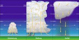
Thunderstorms go through 3 phases:
- Formation
- Maturation
- Dissipation
The stages are illustrated on the scheme.
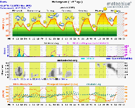
Example
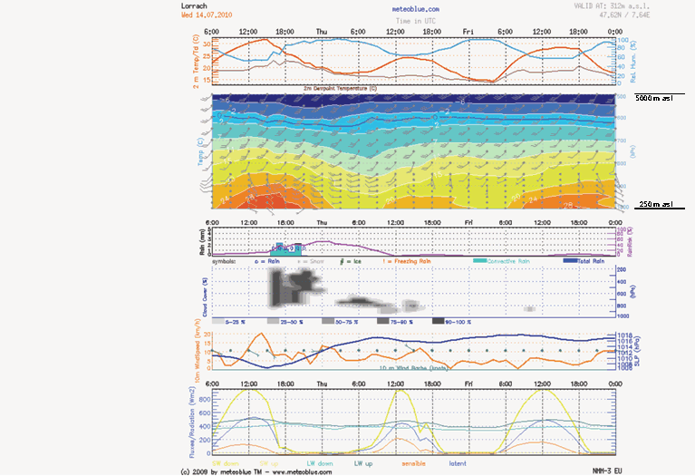
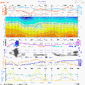
An example of thunderstorm formation on a Meteogram Air is shown on the right.
Questions for training
In the following, you can query and test your knowledge - and above all, apply it. If you are
in doubt, read the text and images above again.
Try it out ;-). We - the meteoblue Team - wish you fun!
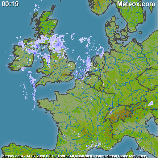
Thunderstorm on the 14th of July 2010 in France
Lille
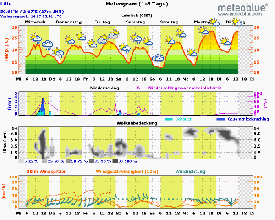
Try to recognise the thunderstorm in the meteogram of Lille (left picture). Do you see the 3 conditions causing the thunderstorm in the meteogramAIR (right picture)?
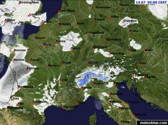
Paris
Paris is also strongly affected by thunderstorms. In the animated radar map (above, right side) you can see how the thunderstorm front passes over Paris.

