
Wind rose
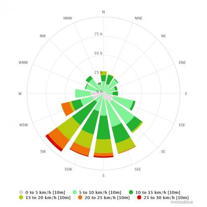
The wind rose is part of the history+ offer. It displays the distribution of wind speed and wind direction at the selected location (where the wind is coming from and with which intensity). Thus, seasons can be easily compared and high-resolution charts with more than 40 years of historical weather simulation data can be easily created and downloaded.
The upper box indicates the time period for which the wind rose is displayed. You can switch to another location by clicking on the location name and compare data. This is only possible for more than one activated history+ location.
The wind rose is available for 10m and 80m above ground and for gust wind at 10m above ground.
You choose between different standards to create a wind rose. The wind rose shows the distribution of wind in percent, hour sum and air mass. With "hour sum" the total amount of hours for each speed class and direction is shown. "Air mass" multiplies each wind class with the wind speed and indicates where air masses are coming from. Otherwise low speeds are too dominant.
The wind rose is subdivided into wind directions, whereas the resolution is selectable. The wind directions are given in North (N), South (S), East (E) and West (W) or in North azimuth degrees (0- 360°):
- N = North (0°)
- NW= Northwest (315°)
- W = West (270°)
- SW = Southwest (225°)
- S = South (180°)
- SE = Southeast (135°)
- E = East (90°)
- NE = Northeast (45°)
For wind speed, there are different units available:
- Kilometres per hour (km/h)
- Meters per second (m/s)
- Beaufort (bf)
- Knots (kn)
- Miles per hour (mph)
The length of the ray indicates the different wind directions. The ray points to the direction from which the wind is coming from. The colour depends on the wind speed.
The grey part of the ray demonstrates calm or at least very low wind speeds whereas green indicates moderate wind speeds in a range of 10 and 25 km/h. The darker the green, the windier it is. Yellow rays represent a wind speed range of 25 to 30 km/h.
The yellow colour of the ray becomes darker as the wind speed is increasing and 68km/h (pink) is the maximum wind speed displayed in the wind rose. You can choose the resolution of the wind speed ranges and use the mouse-over function for more details.
You can download raw weather data as CSV files and further processed with programs like Microsoft® Excel or OpenOffice, by clicking on “Download as CSV”.

