meteoblue depends on cookies for best online experience, to analyse site usage and personalise advertising and content, for which we need your consent.
To learn more: Privacy & Terms. Please let us know if you agree.
Find out how to use our Weather Maps interface and its wide range of functionalities
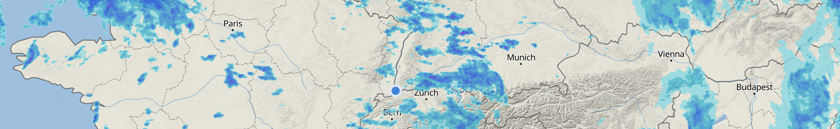
Assess the current weather in real-time with the worlds’ best Satellite & Radar animation
Watch the smoothest wind animation for any place on Earth
Enjoy our intuitive design, seamless graphics, and interactive interface
Explore hundreds of different weather maps with our unique range of variables,
models and elevation levels, up to 7 days into the future
Utilise our advanced settings, enabling customised overlays, model selection,
and easy sharing within your networks
Weather data visualisation has always been one of the core competences of meteoblue.
Our iconic wind animation map was first launched in 2006,
and has shaped the industry standard ever since.
We have gradually expanded our weather map portfolio,
and now offer more freely available weather maps than any of our competitors.
"Impressive site and since I have a wx station within just hundreds of feet I have been monitoring your details in comparison. Considering the dynamics of coast weather here in this area the general accuracy is high. I am extremely impressed with the weather maps and their use. Kudos to those who put this all together."
Donald T., meteoblue user, 09.06.2022
"Hi Meteoblue, Just a short feedback on the new Weather Maps pages - they look great but please please please can we keep the Observations section; most importantly the METARs, These are so valuable [...] Thanks so much for all your work. Meteoblue is certainly a leader in met data and forecasting. Best regards."
Anonymous, meteoblue user, 20.02.2021
"Your wind show is the best I have ever seen. Good going."
Ebbe S., meteoblue user, 07.06.2019
Navigation & Legend
Note
The maps are available worldwide,
with the size and resolution depending on the desired
area,
variable,
time and model
resolution.
The design of the features described below can differ slightly,
depending on the individual maps.
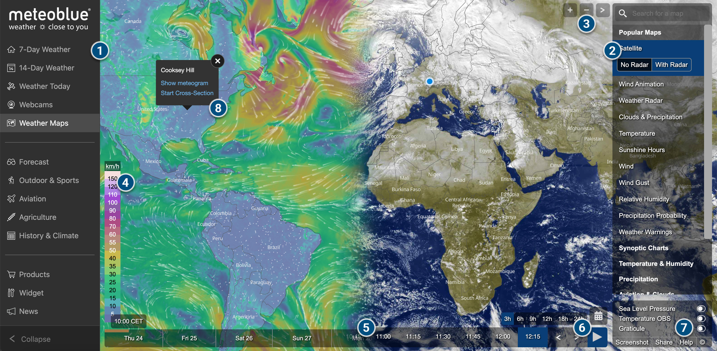
On the left-hand side, you can see the meteoblue.com navigation menu,
as seen on every page on meteoblue.com
(or just the menu icons, if it is collapsed on smaller screens).
On the right-hand side, you can find the main maps menu,
where you can switch between map categories, the maps within the categories,
and different variants and elevation levels of the individual maps (when available).
Near the top right corner, you can find the + and – buttons for zooming,
and the > button for collapsing the right-hand side menu.
On select maps, you can find a vertical colour-bar on the bottom left.
This bar explains the colour-coding of the map, as well as the map units,
which can be edited where applicable.
At the bottom of the map, you can see the horizontal time slider.
This element shows the time extent of the forecast, the moment currently displayed on the map,
and it enables you to slide between different moments in time.
For real-time animations (Satellite, Weather Radar) there is a “Play” button to initiate the animation.
Once the animation is playing, an element on the right-hand side of the bar will indicate the time.
Its background will turn blue once the radar animation is displaying forecast-data.
By clicking on the calendar icon, you can access historical satellite images from 2019 onwards
(requires point+ subscription)
The advanced settings can be found in the bottom right corner (see 6 in picture above).
Here you can add overlays such as Wind Animation, Sea Level Pressure, Temperature OBS (i.e., observed), or Graticule.
You can also use this section to generate a screenshot or a shareable link, view the help pages (i.e., these pages),
and check the attributions under copyright information.
By clicking on any location on the map, you can access further options for location-based information:
Show meteogram – Opens the Meteogram
All-in-One
for the requested location
Start Cross-Section – Allows you to draw a flight track on the map
and provides a Cross-Section diagram along this route
(requires point+ subscription)
METAR – To access a comprehensive version of METAR reports,
just click on the respective airport on the METAR map
meteoblue Weather Maps
The video below provides a quick overview of some of the key features of our Weather Maps, such as the
satellite animation, the radar layer, and other essential features of the map interface.
Categories
Our weather maps are aggregated into 9 categories for easy orientation:
For our versatile API solution, allowing the integration of
fully customisable meteoblue weather maps into your company interfaces,
visit the Maps API page.