
Clouds
meteoblue shows cloud cover for 56 layers in the atmosphere.
Cloud cover is expressed in % of the maximum cloud cover. Cover is often grouped in classes of 0-25%, 25-50% etc.
Zero percent means that there is no visible cloud in the sky. Fifty percent is equivalent to half of the sky being covered with clouds. Hundred percent cloud cover means no clear sky is visible. If cloud cover in several layers is fifty percent, then only a low percentage of sky will be visible.
Percentages are calculated as integral of the preceding forecast period. Variations during that period are integrated into an average.
meteoblue cloud forecast are delivered as aggregate forecast, in aggregate layers (low/medium/high) or in selected layers fit-to-purpose.
Aggregate cloud layers are defined according to WMO as:
- low clouds: from the surface - 2 km (from the surface -2 km at equator)
- medium clouds: 2-7 km (2-8 km at equator)
- high clouds: 5-13 km (6-18 km at equator)
Under tropical conditions the cloud altitude can reach 1 to 3 km more than indicated. From the height, density and sequence of the clouds, you can interpret the type of weather expected (see below). A typical cold front starts with low clouds, which build up over time. Thunderstorm weather is characterised by cloudless mornings and rapid cloud development during the day, with dense and high clouds in the afternoon, which may disappear again during the night.
meteoblue cloud forecasts are used for varied purposes, including leisure, astronomy, solar power forecasts or flight planning.
Examples of cloud forecasts are shown under the point meteograms, Pictocast, spot and under cloud maps. Special cloud forecasting services, including local fog prediction, can be provided on request.
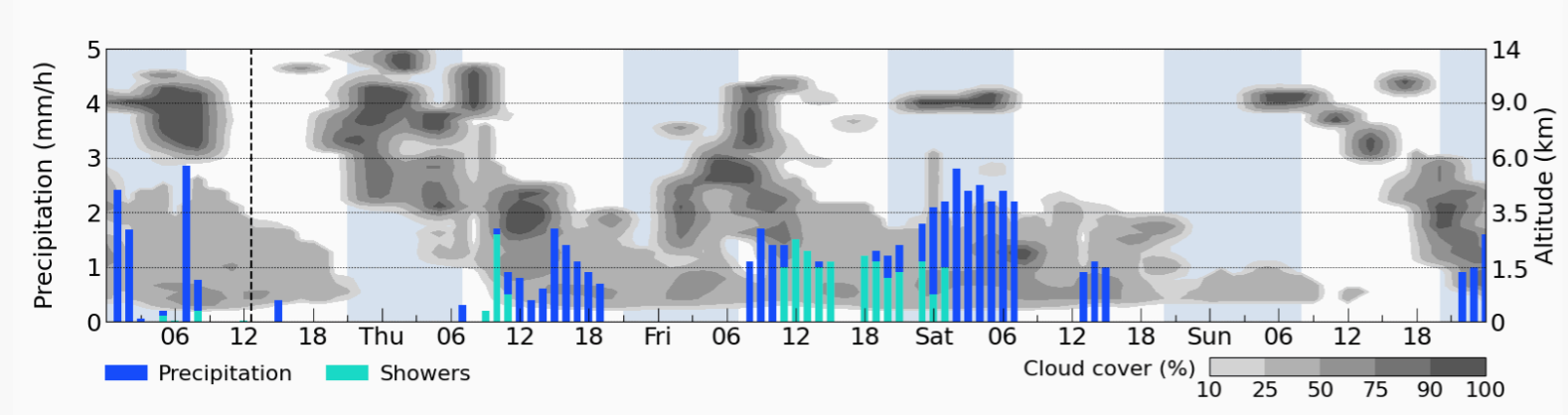
Quantification of cloud cover
Cloud cover is expressed in percent (if not otherwise indicated), from 0 to 100%: 100% means that no clear sky is visible. Cloud cover may be expressed as percent on each level. The total cloud cover is not the addition of cloud cover % in different layers. Examples:
- low, medium and high cloud cover of 50% each may add up to 100% cloud cover, but not to 150%.
- low and medium cover of 50% or less combined with a high cloud cover of 100% will add up to 100% cloud cover, but can be much more translucent than below a low cloud cover of 80%, depending on the cloud types within the high cloud cover.
- low and medium cloud cover of 50% each may add up to 60% total cloud cover, because some clear sky can still be seen.
The total calculated cloud cover depends on the types of clouds present, and can not be derived from the cloud cover of individual layers. For more precision on the effect of cloud cover, use the radiation variable.
Measure of cloud cover
Measuring cloud cover is very difficult in practice. The most frequently used sensors are
satellite cameras, which provide an overview of coverage, but can not distinguish well between low, medium and high
clouds. Ground sensors can determine cloud cover and altitude to a certain extent, but only for a limited area.
Visual observation is (still) very frequent for cloud determination, using a scale from 0/8 (no clouds) to 8/8
(complete sky cover); these observations are used for the METAR reports.
Significance of cloud cover
Cloud cover has a significant effect on the temperature forecast. The quantity of solar energy
reaching the surface is a strong determinant of surface temperature.
The troposphere is heated through solar
radiation that reaches the Earth's surface. Fluctuations in this solar energy change the surface temperature, where
most temperature measurements are made. Clouds act as a regulator to the amount of solar radiation that reaches the
surface.
During daytime, clouds reduce the temperature, depending on the cloud thickness, cloud density and
time of permanence. If the cloud cover stays longer than expected during the daytime, surface temperature will
generally be cooler than expected. If there is less cloud cover than expected, surface temperature will generally be
warmer than expected. One example of this situation occurs when fog or a low stratus cloud cover is present,
especially during cooler season. A fog or low cloud cover is difficult to forecast, because it often only forms
locally. If the fog does not dissipate when expected, surface temperature forecast will deviate significantly.
At night, clouds have the opposite effect on temperature. More cloud cover than expected at night usually results into warmer temperatures than expected. Less cloud cover results in cooler temperatures than expected. The reason is that at night, the earth's surface emits energy in the form of long-wave radiation and does not receive any short-wave radiation from the sun to heat the surface. Water vapor intercepts long-wave radiation, radiates it back to the ground and prevents it from escaping into space. This results in warmer air temperatures. On a clear night, a maximum amount of long-wave radiation will escape into space (unobstructed) and thus surface temperatures will cool at the maximum rate for the given weather conditions.
Clouds are also triggers for precipitation. By influencing temperature, different processes in clouds have a complex effect on the condensation point. Generally, lower cloud temperatures will increase the precipitation probability under such circumstances. However, thunderstorms will only form if warm and humid air rises above the condensation level and thus acts as an energy supplier. If cloud cover causes the boundary layer to be cooler than expected, it could prevent the capping inversion from being broken in a thunderstorm situation. If the cap is not broken, in many cases no thunderstorm precipitation will occur. Conversely, a reduction of cloud cover can enhance instability during the day and increase the thunderstorm threat.
To sum up, the ability to predict cloud development and movement is fundamental to the calculation of a reliable weather forecast.

