
WaterApps
The WaterApps consortium brings together a diverse range of organisations, including universities, businesses partners from the private sector, public authorities, and local institutions in Ghana and Bangladesh. The program is funded by Netherlands Organisation for Scientific Research (NWO) and is coordinated by the Water Systems and Global Change group at Wageningen University.
The WaterApps research program aims to develop tailor-made water information services with and for farmers in peri-urban areas in the urbanising deltas of Accra, Ghana and Khulna, Bangladesh to improve water and food security in river deltas.
WaterApps achieved its objectives through interconnected research components. The resulting insights are used to co-create and test water information services, consisting of knowledge sharing platforms and virtual communities.
meteoblue has become the weather data provider for the project, as we provide high quality short term forecasts, our organization is transparent about its forecast development, and offers a detailed background to the forecasts.
Customer success story:
When water becomes scarce
Picture this:
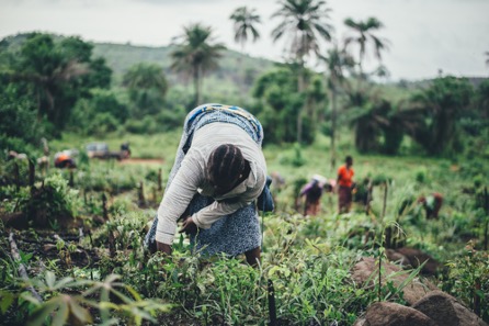
You are a farmer who lives in the developing world. You live in a vicinity of a large city, near a river delta. As the population in the area grows and the climate changes, your access to water becomes more and more scant and unpredictable. This in turn leads to anxiety about the harvest on which your family's livelihood depends.
The crucial question is: In this situation, how do you obtain reliable and accurate information about the present and future levels of available water?
Well, if you happen to live in the areas of Khulna (Bangladesh) or Accra (Ghana), we have a solution for you.
WaterApps project
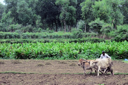
The aim of the WaterApps project is to develop and offer custom-made water information services. The beneficiaries are small and medium-sized private farmers in peri-urban (i.e., located in the city outskirts) river delta areas, where water level fluctuations have massive impacts.
How is it done?
- By combining information technology (a mobile phone app) with latest insights on knowledge sharing.
- By integrating numerical weather model outputs with actual observations of groundwater trends and river flows.
- By attuning knowledge about adaptive decision-making and enabling governance structures to local situations.
Background
The WaterApps consortium unites a diverse range of organisations, from universities to businesses partners from the private sector, public authorities and local institutions in Ghana and Bangladesh. The program is funded by Dutch Organisation for Scientific Research and is coordinated by the Water Systems and Global Change Group at Wageningen University. meteoblue, a Swiss-based weather data company and a proud partner of WaterApps, supplies premium weather information for Tamale and Ada (Ghana), Khulna (Bangladesh).
From the very beginning, it was clear that the involvement of the farmers themselves was going to be one of the key factors. Therefore, as Spyros Paparrizos, an Assistant Professor of Climate Information Services at the Wageningen University and the principal investigator of the WaterApps project describes, in 2015, the WaterApps consortium organised workshops with all parties involved (farmers, governance actors and ICT professionals) in both countries, Bangladesh and Ghana. The resulting co-production of water information services with local farmers improves their livelihoods, and builds the capacity for enhancing sustainable food production. Furthermore, it proves to be a workable modus operandi for delivering design principles for viable farmer-oriented water information services in other urban-rural delta zones in the developing world.

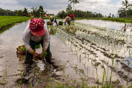
How it works in practice - Samiron and Ela's stories
In order to monitor if all aspects of the project are running smoothly and also to increase the awareness of the project, the WaterApps team recently visited local farmers in their villages and conducted a variety of educational workshops in order to demonstrate to them how to take advantage of weather information for farming and daily life.
The extensive high quality local weather information available for free on the meteoblue web site was an ideal teaching aid. As a result, meteoblue has become popular amongst the local farmers and general public in the area.
To quote Samiron Golder, farmer in Khulna:
“As a farmer, my aim is to be engaged with modernisation. We should not be afraid of natural disasters, but by being engaged with weather information services we can try to reduce the risks of disasters. [...] With our many disappointments, the meteoblue forecast information is like a piece of light for us.”
Samiron's full story can be found here.
Ela Ganguli, who is also from Khulna, Bangladesh, works not only as a farmer, but also as a farming consultant in the area, helping others optimise their farming techniques.
She adds:
"I usually got agricultural information from the agricultural office and related apps. I believe that climate is the basis of all agriculture. From meteoblue, I receive weather updates for 7 days, 15 days, and 3 months about temperature, humidity, rainfall, wind speed, thunderstorms, etc."
The entire video can be seen here.
Future plans
As the WaterApps concept continuously shows that it is a working model, there's hoping that in the future, the project's scope will expand into other areas as well. Christoph Ramshorn, the Chief Cooperation Officer of meteoblue, says: "This whole project represents the very core values of our company, and therefore, as it expands, we will remain committed to delivering Swiss-quality weather data to any necessary number of locations worldwide."

