rainNOW is a nowcasting service based mostly in telemetry data which shows precipitation
information for the vicinity of a location in 15-minute steps. rainNOW is updated every 15 minutes with t
he latest precipitation forecasts, 24 hours
a day.
As of the year 2014, rainNOW is available for Switzerland and Central Europe including the
British Islands. For commercial uses, rainNOW is available through
the meteoblue API data packages.
rainNOW is a good decision making tool for users who need:
- always up-to-date precipitation information for defined locations;
- the ability to observe progress of precipitation over time;
- an overview of the detailed precipitation in surrounding areas;
- a simple affordable system to monitor precipitations in short term intervals.
rainNOW offers the precipitation - spot on.
How to read rainNOW?

The circles show the distance from the center. North is at the top, West on the left, South at the bottom and East on the right (as in any map). The shown area aggregates neighbouring grid cells, assembled in a way that the selected location is in the center grid cell.
The radius of the rainNOW graph is shown on the left of the graph.

rainNOW shows you the expected and past precipitation in short time steps.
The local time is shown as
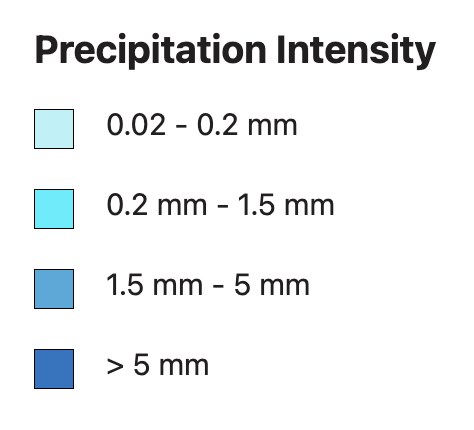
hours and minutes (hh:mm) above each diagram. The precipitation amount of the last 15 minutes is shown below the
spot and is classified into 4 categories that you can see on the picture on the right.
The precipitation may fall as drizzle, rain, hail, ice or snow. More information about the conversion of water equivalent into snow height is available on our precipitation page.
The rainNOW diagram is updated every 15 minutes. Thereby, precipitations for all the locations in the area are recalculated.
Data sources
rainNOW is based on telemetry (remote sensing) observations, such as radar, satellites and aerial pictures. In some cases, ground measurements may be used.
Accuracy
The accuracy of rainNOW can differ depending on the area, because it depends partially on observational data, which are not of uniform quality and availability. In situations of low intensity (i.e. drizzle, fog, snow showers) and in undulating areas (e.g. mountains), the difference to reality can become significant. The accuracy also declines with the length of the forecast (from 15 up to 120 minutes).
The accuracy of rainNOW measurements is not suited for quantitative purpose (measurements, warnings etc.). The amount of precipitation can be looked up in the point meteograms.


