
Mathias Müller
Chief Innovation Officer
meteoblue AG
"meteoblue offers hundreds of intuitive and interactive Weather Maps, including state-of-the-art real-time satellite and radar animations."

Relevant links
Features
Technical documentation
More free offers
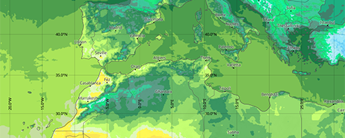
meteoblue weather maps offer a wide range of globally available weather variables, data sources and height levels. Real-time satellite images, weather radar and cutting-edge animations provide perfect visualisations. Enrich your web application with an easy to integrate plugin within minutes.
We would be pleased to support you with a free API trial access upon request.
Carefully crafted map designs with just the right amount of detail ensure high usability and visual appeal for both, casual users and experts alike. The choice of colours, labels, contours and available maps is based on a deep understanding of cartography and the underlying weather data.
Map tiles and open standards guarantee high performance and great compatibility.
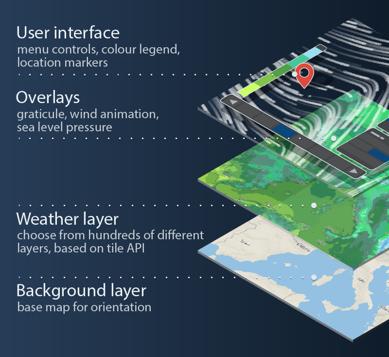
Our easy to integrate plugin for Mapbox GL JS, which uses our map tiles API under the hood. It features a ready-to-use web interface, similar to the Weather Maps on meteoblue.com. The wind animation was developed from ground up to provide unmatched performance and levels of detail. The satellite and radar maps show current weather data as a seamless minute-by-minute animation. The radar animation includes a forecast for one to up to two hours ahead.
After simply dropping in the plugin with a script tag, it adds controls to an existing Mapbox GL JS map for a map selection menu, time selection and a legend. Easily choose which maps should be available in the navigation. Customise the UI design to match the visual appearance of your website.
The JavaScript API provides methods and events similar to Mapbox GL JS, to allow for small tweaks up to completely replacing the default user interface. Add your own content through the powerful Mapbox GL JS API, for example custom HTML markers or popups.
The video below provides a quick overview of some of the key features of our Weather Maps, such as the satellite animation, the radar layer, and other essential features of the map interface.
|
|
|
|
|
|
Mathias Müller
Chief Innovation Officer
meteoblue AG
Use the underlying low-level Tile API for fully customised solutions. It provides standard vector and raster tile formats, compatible with all common mapping libraries, like Mapbox GL JS, Leaflet, OpenLayers and others.
The API supports 80+ different weather variables, multiple weather models and different height levels, single time steps and aggregations, fully customizable contour steps (e.g. 2 °C or 4 °C temperature steps) and customizable map colours as well as multiple units of measurement.

If you have any questions or need advice, please get in touch. Our expert on the meteoblue Maps API will get back to you shortly.
Michaela Schlögl
Head of Sales & Support


